Use the Set Missing Geospatial Information dialog to select the default parent of the geospatial hierarchy in the query. The purpose is to define the country (and state, where relevant) of the cities or zip codes in your query.
Set Missing Geospatial Information
When adding a geospatial hierarchy to the query at a level lower than country, this dialog will open by default:
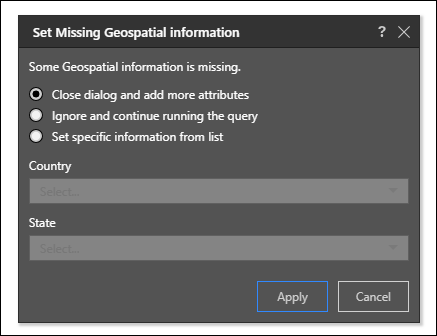
When adding low level hierarchies like cities, you'll see the Set Missing Geospatial Information dialog. You can:
- Close the dialog and add more attributes: choose this option if you have not finished adding hierarchies to the query.
- Ignore and continue running the query: choose this option if you don't want to select a country, and you want to run the query.
- Set specific information from list: select this option to specify a country from the dropdown list. You can also select a state if relevant.
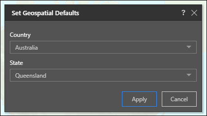
You can also open the Geospatial Defaults dialog from the Component ribbon (for example, if you want to select a different country).
Because many cities and suburbs in different countries have common names or postal codes, Pyramid enables you to define which country the given cities are in. For instance, you may add a list of cities in the UK to your query. However, a number of cities outside of the UK share names with several UK cities. In this scenario, you can open the Geospatial Defaults dialog and set the Country as United Kingdom, so that only cities within the UK will be plotted on the map.